Page 1 of 1

The Ox Wagon Route

Posted: Wed Oct 31, 2012 5:19 pm
by Trailrider
"It is, perhaps, not just the journey that counts, but also the road that is travelled. And it's not necessarily the high road or the low road that matters, but rather the story behind the road that's important."

From early days a need for a link between the coast and the interior existed. With the arrival of white settlers at the Cape, the need for a route between the Cape and the interior enjoyed a high priority. But it was a time before great road builders like Bain came along and traveling over the mountains of the Southern Cape was all but impossible. It took a special kind of person, a pioneer, explorer and adventurer all in one, to look for and navigate new routes over these treacherous mountains.

Today when we travel on the routes these remarkable individuals opened up, we do so in luxury with little effort and in a fraction of time. They did it with great danger to themselves. We do it as a pastime or a holiday. But lets never forget the remarkable achievements of those that has gone before. We honour them by keeping the history alive.


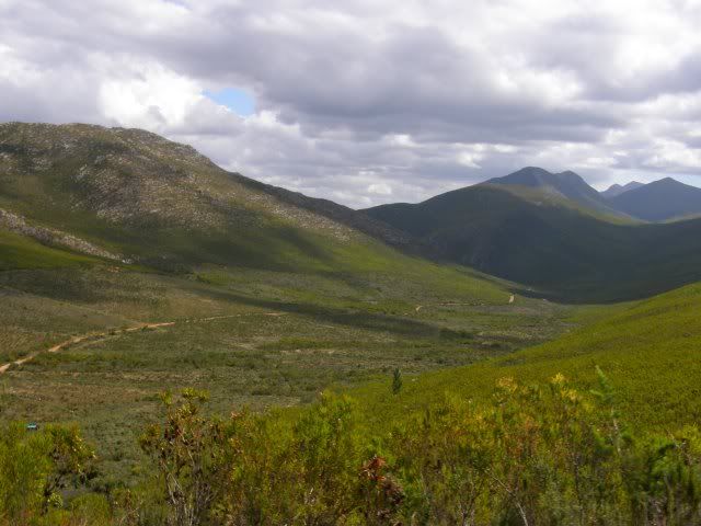
The Ox wagon Route in the Southern Cape is a modern day route, connecting various historic passes and routes that the ox wagons of old had to conquer.

The route travels over various mountain ranges and 4x4 tracks following in the footsteps of the first Pioneer Trekkers. The area is blessed with amazing natural beauty and that in itself makes it worth traveling, but if you do not travel informed you miss out on so much as it's rich history truly makes this a route to remember.

I have done portions of this route before on my motorbike, but some areas on this route is off-limits to motorbikes for various reasons. Having access to vehicles of all kinds I decided to tackle this route again on four wheels, like the ox wagons of old did.

This report will be divided up in sections and will be updated as I go along. Hopefully it will be of some use to 4x4 enthusiasts visiting our wonderful area.

Image

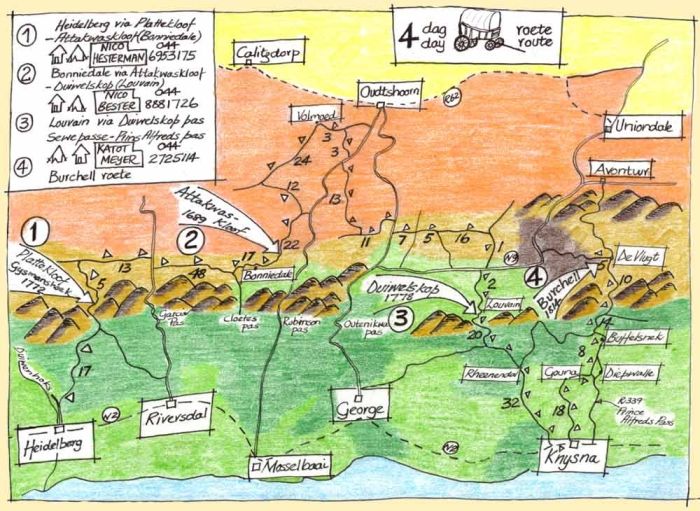
Map from Katot Meyer's website here.

Re: The Ox Wagon Route

Posted: Wed Oct 31, 2012 5:41 pm
by JEEPIE
so lets go
i wanna hear more

Re: The Ox Wagon Route

Posted: Wed Oct 31, 2012 5:45 pm
by pietpetoors
That is a trial I would like to do so I cannot wait for the pictures

Re: The Ox Wagon Route

Posted: Wed Oct 31, 2012 5:47 pm
by Trailrider
Battling to post the next section. For some reason when I submit it doesn't go through.

Re: The Ox Wagon Route

Posted: Wed Oct 31, 2012 5:49 pm
by Trailrider
Still battling. Can post short sections but not whole sections. Will see if I can continue tomorrow with a better connection.

Re: The Ox Wagon Route

Posted: Wed Oct 31, 2012 10:00 pm
by pietpetoors
I can see here comes a long story. Waiting in anticipation.

Re: The Ox Wagon Route

Posted: Wed Oct 31, 2012 10:05 pm
by STAMPIE
Johann
Ek het dit ook al 'n paar maal gedoen. Een van die mooiste en interessantste trips om te doen.
Veral met karakters soos Nico Hesterman en Katot Meyer. Manne met byna onuitputlike bron van kennis oor die geskiedenis van daai wêreld en met wie jy ure om 'n vuur kan kuier.
Sien uit na die "report"

Re: The Ox Wagon Route

Posted: Wed Oct 31, 2012 10:18 pm
by Trailrider
The Ox Wagon Route starts near Heidelberg in die Western Cape from where it crosses the Langeberg mountains via Gysmanshoek Pass into the Klein Karoo.

Gysmanshoek Pass, or Plattekloof Pass as it was also known, was opened up in 1740 by the Trekboers (migrant farmers). It was well used and even mentioned by famous explorers William Burchell and the botanist Carl Thunberg in their travel diaries.

The historic pass lies between way-points S33 58.220 E21 03.085 in the south and S33 53.468 E21 03.604 in the North.

It is an easy start to the Ox Wagon Trail as Southern Cape passes go, but interesting nonetheless. It runs through three farms, Plattekloof in the South, then Kanetberg and Kortfontein on the Karoo side.

The scenery and flora changes dramatically as to cross to the Northern slopes turning into typical fynbos and eventually Karoo vegetation. The Southern portion though is lush and green:

Image Link Broken

But that changes soon as you start to enter the mountains.

Image Link Broken

The track is generally in good condition and once in the mountains you are alone with little or no signs of civilization around. Just the way I like it.

Looking back - notice the contrast, how much greener the side facing South is:

Image Link Broken

Gysmanshoek Pass runs through this gentle valley, a very easy road to build in those times. And yet, about 120 years after this route to the Klein Karoo opened they chose to build the Tradouw pass, a massive undertaking over very challenging terrain, instead of upgrading Gysmanshoek Pass. It almost makes no sense until you consider what it was like in the days of animal drawn vehicles.

When the inhabitants of Swellendam wished to get to the Little Karoo on the other side of the Langeberg they had to travel either via Cogmans Kloof 50 kilometres to the west, or via Gysmanshoek, 30 kilometres to the east. Huge distances in those days worth days of traveling time. This of course also applied to Little Karoo farmers who wished to transport their produce to Port Beaufort on the Breede River, which Joseph Barry had opened to shipping in 1841.

After the construction of the Tradouw and Garcia's passes in 1873 & 1877 respectively, Gysmanshoek Pass fell in disuse. It came in handy for a Boer Commando during the Anglo-Boer War though, when they used Gysmanshoek Pass to flee back to the Karoo after attacking the headquarters of the West Yorkshire Regiment at the Masonic Hotel in Heidelberg on the 14th of September 1901.

Today the road is seldom used, mostly by local farmers.

Image Link Broken

William Patterson wrote about crossing the Langeberg in 1777. He commented in his journal: "Upon reaching the summit of the mountain, we were presented to the south with a view to the sea, and on the North... the Channa Land and Karoo."

Image Link Broken

Looking back at the pass from the Karoo side:

Image


Not the most challenging pass you'll encounter, but the remoteness and solitude will more than make up for that. You are unlikely to encounter other traffic on this pass. I never have.

From here you continue East on well maintained gravel roads along the Langeberg mountains to the Gouritz river and beyond to the next portion of the Ox Wagon Trail - Attaquaskloof.

Image Link Broken

Re: The Ox Wagon Route

Posted: Wed Oct 31, 2012 10:20 pm
by Trailrider
Admin, the post only goes through when I tick "Disable BBCode".

Have a look at my post and see what in it is causing the problem?

Can you fix?

Re: The Ox Wagon Route

Posted: Wed Oct 31, 2012 10:38 pm
by Trailrider
I finally got an error message: "It was not possible to determine the dimensions of the image."

Re: The Ox Wagon Route

Posted: Wed Oct 31, 2012 10:53 pm
by Mud Dog
send the images to me ( andy@hilux4x4.co.za ) and I'll edit them into your post ;-)

Re: The Ox Wagon Route

Posted: Thu Nov 01, 2012 9:31 am
by HennieO
Can't wait for this one!! :thumbup: :thumbup:

Re: The Ox Wagon Route

Posted: Wed Nov 28, 2012 9:58 am
by Trailrider
Mud Dog what am I doing wrong. I can't mail you the pics of every single report. :mrgreen:

I am active on a lot of forums. First time I'm battling to post a pic. What am I missing?

Re: The Ox Wagon Route

Posted: Wed Nov 28, 2012 10:10 am
by pietpetoors
99.95% of the time the problem is that the pics are to big.
See some tips at
viewforum.php?f=21" onclick="window.open(this.href);return false;

Re: The Ox Wagon Route

Posted: Wed Nov 28, 2012 10:29 am
by Trailrider
Dankie pietpetoors. Het gaan loer. :cool:

Re: The Ox Wagon Route

Posted: Wed Dec 19, 2012 9:50 am
by Trailrider
Hi guys.

This report is coming along nicely, but it seem the only way I can post it here is to resize everything from the start, reload everything to photobucket again, etc. I.o.w. redo everything. That is a very big and time consuming job and this is December holidays so the chances of me doing everything over is slim to zero. :mrgreen:

But those who do want to follow this report can also do so on my blog:

http://trailriderreports.blogspot.com/2 ... st_19.html" onclick="window.open(this.href);return false;

Sorry for the inconvenience.

:surrender:

Re: The Ox Wagon Route

Posted: Wed Dec 19, 2012 11:15 am
by SideKick
I did that trail last year. Was the second trail I ever did. Very nice!!!

Did you turn off the main road on drive up to that lookout point?

My Hilux signature below, that photo was taken on that peak. What a nice climb to get up there! A little overgrown though. Don't do it if you don't want scratches!!!

But I just did the part from Wildernis across and back again. The Louvain pass I think . . . Never knew about the rest :(

Re: The Ox Wagon Route

Posted: Wed Dec 19, 2012 11:29 am
by SideKick
Trailrider wrote:Hi guys.

This report is coming along nicely, but it seem the only way I can post it here is to resize everything from the start, reload everything to photobucket again, etc. I.o.w. redo everything. That is a very big and time consuming job and this is December holidays so the chances of me doing everything over is slim to zero. :mrgreen:

But those who do want to follow this report can also do so on my blog:

http://trailriderreports.blogspot.com/2 ... st_19.html" onclick="window.open(this.href);return false;

Sorry for the inconvenience.

:surrender:
Use Microsoft Office Picture Manager. Change the view to thumbnails. Select all the photos. Click edit picture at the top. Click resize on the right. From the pre-defined list, select 800 x 600. Click OK. Close the program and then say yes to save changes. Takes less than a minute to resize all your pics at once :thumbup: